We use cookies, along with some third-party sites (like Google, Facebook, etc.). By continuing to visit this site you agree to our use of cookies.


- Search Yachts
- Destinations
- Company
- Sailing info
- Blog
Need help? Contact us

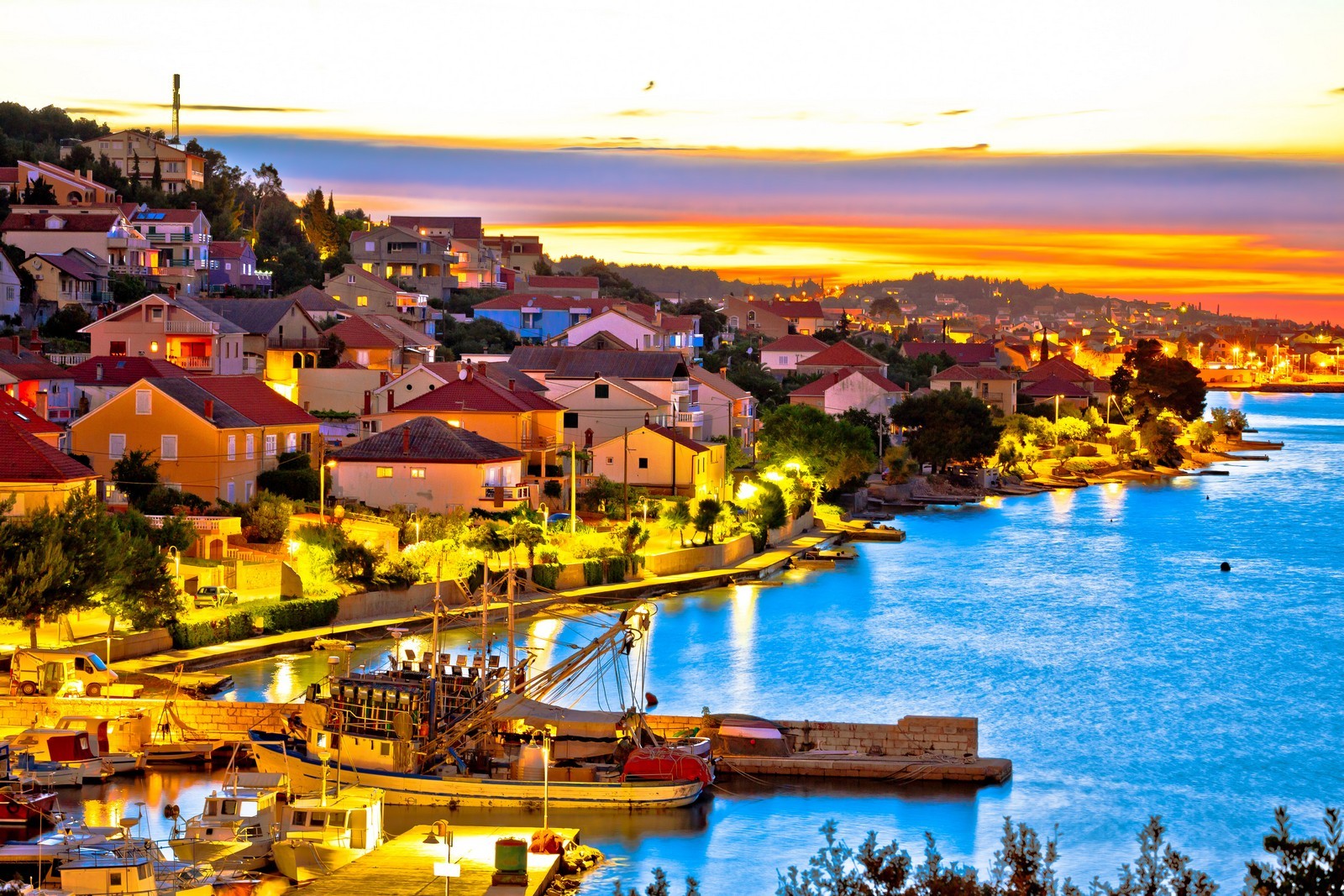
An island in the Zadar archipelago. It is separated from the mainland by the Zadar Channel and from the island of Pasman by the narrow Zdrelac Strait, which is spanned by a bridge. Scah (286 m) is the highest peak of the karstic ridge which runs along the island. The southwestern coast is steep and less accessible than the northeastern one, which is lined with bays, harbours and settlements. Ugljan is one of the most densely populated islands on the Adriatic. All the settlements, Ugljan, Lukoran, Sutomiscica, Poljana, Preko, Kali and Kukljica, lie on the northeastern coast. The island was first mentioned in written sources by its present name in 1325, but it has been inhabited since the Neolithic period. The remains of lllyrian forts and traces of the Roman era are still visible in some areas. All present settlements were built in the Middle Ages.
KALI - A large, typically Mediterranean settlement and fishing port on the southeastern part of the island between the Kali and Batalaza Bays. The off-shore islet of Osljak lies in the Pasman Channel. The settlement was first mentioned in 1343. The Baroque church was built in 1689. On a knoll above the settlement stands the Church of sv. Pelegrin (St. Peregrine) from the 14ft century. Its two harbours are mostly occupied by fishing boats, so boats can only raft up to one of them.
KUKLJICA - A settlement with a small port on a bay of the same name on the southeastern part of the island. It is the most developed tourist centre on the island and features numerous bays with excellent beaches and thick pine forests. The most famous beaches are Sabusa and Jelenica (a naturist beach). On a pine-covered cape at the Zaglav Bay lies a tourist settlement with sports and recreational facilities. Kukljica was first mentioned in 1345. The Church of sv. Pavao (St. Paul) was built in 1666. The harbor is well protected, and only the southeasterly wind can cause waves. In the harbor lies a small marina with water and electricity hook-ups, a launch ramp and a small shipyard.
LAMJANA VELA - A long and narrow bay with a shipyard at the end. It is exposed to southeasterly winds.
LAMJANA MALA - A deep and slightly wider bay with a fish farm in the eastern and western parts. It is exposed to southeasterly winds.
LUKORAN - A settlement on a bay of the same name in the central part of the northeasterly coast. It is surrounded by fertile fields, olive groves and vineyards. The main occupations of the inhabitants are fishing and tourism. A private campsite, a beautiful beach and a pine forest lie on the coast. Lukoran was mentioned in 1075. In the Middle Ages, it was the property of the Zadar Benedictines. The cemetery church, which was reconstructed in the 17lh century, has a few Romanesque characteristics. The harbour is exposed to northerly and northwesterly winds. The tide is strong. Berths are available at the northern and southern coasts at depths between 2 and 3 m, or at the pier with a depth of 2 m or less.
POLJANA - The smallest settlement on the island is suitable for a peaceful vacation. The harbour is unreliable when the jugo blows. Boats can berth at the breakwater with a depth of up to 2.5 m, if there is space. There is a launch ramp.
PREKO - A settlement with a ferry landing (Zadar) in the central part of the northeastern coast. It is the largest town on the island and its administrative and transit centre. The coast is suitable for swimming, particularly on the islet of Galovac. The tourist area of Preko includes the neighbouring settlements of Sutomiscica and Poljana, and the off-shore islet of Osljak. Preko was settled in the Roman era. The Romanesque Church of sv. Ivan Krstitelj (St. John the Baptist) dates back to the 12lh century and the Baroque parish church was built in 1765. On a knoll in the middle of the island southwest of the settlement lie the ruins of the medieval Fortress of sv. Mihovil (St. Michael) from the 13th century which affords a view of part of the Zadar archipelago. In front of the port lie the wooded off-shore islet of Galovac with a Franciscan monastery from 1443, and the islet of Osljak.
There are three harbours in the settlement but space for berthing is hard to find. The northern one lies in a small bay protected by the islet of Galovac and a breakwater with a depth of up to 2.5 m. It is exposed to northerly winds and has a launch ramp. Boats can berth at a small pier with a depth of 1.5 m. The middle one is protected by a breakwater where boats can berth at a depth of up to 4 m. Behind it lies a small inner harbour for smaller boats. The harbour is exposed to northerly winds. The southern one is the aforementioned ferry landing, where boats can berth only briefly. Berths are also available at a small pier. The depth of the sea is between 2 and 2.7 m.
SUTOMISCICA - This picturesque settlement on a bay of the same name is suitable for a peaceful vacation. The Church of sv. Eufemija (St. Euphemia) was mentioned in 1349. The present church dates back to 1679. There is an unusual cemetery next to the church. The harbour is well-protected from all winds except the northerly. Berths are available at a small pier at a depth of up to 2 m, or in a small marina.
UGLJAN TOWN - A large settlement with a port on the northeastern part of the island. The most popular of the sandy beaches lies in the Muline Bay northwest of Ugljan. There are a few private campsites in the settlement and its environs. The Franciscan monastery with the Church of sv. Jerolim (St. Jerome) from 1447 stands on a cape at the port. On the Muline Bay lie the remains of Roman farm buildings with water reservoirs and an oil mill, an Early Christian cemetery from the 6th century and a mausoleum with floor mosaics and frescoes from the 5th century. The harbour is protected by a breakwater. Boats can berth only at the beginning of the breakwater at a depth of 3 m, because the depth gradually decreases. The depth of the sea in the harbour does not exceed 1 m. In Ceprljanda lies a harbour protected by a breakwater which has berths for boats with a draught of up to 3 m. The depth at the first, smaller pier is 1.5 m. The harbour is exposed to northerly winds.
MULINE - A small settlement on the northeastern side of the island on a bay of the same name. Boats with a draught of up to 2.5 m can berth at a curved pier in the harbour. The depth decreases towards the end of the pier and there is a shoal in the knee. The bay is exposed to northwesterly winds.

We are very social bunch. Get in touch!