We use cookies, along with some third-party sites (like Google, Facebook, etc.). By continuing to visit this site you agree to our use of cookies.


- Search Yachts
- Destinations
- Company
- Sailing info
- Blog
Need help? Contact us

The largest island in the Central Dalmatian island group and the third largest on the Adriatic. Its highest point is Vidova gora (780 m), which is also the highest peak on all the Adriatic islands. It is separated from the mainland by the Brac Channel, from the island of Solta by the Splitska vrata Strait and from the island of Hvar by the Hvar Channel. Its landscape is characterized by karst phenomenon, such as fissures, caves and hollows. There are no surface streams and the only permanent springs are located around Bol.
Supetar and Pucisca are the largest of the 22 settlements. The most important agricultural products are olive oil, wine and fruit, but the inhabitants also engage in livestock breeding, fishing (fish canneries in Postira and Milna) and tourism. Several quarries with the famous white stone which was used in the construction of Diocletian's Palace in Split and the White House in Washington D.C. are scattered throughout the island. The settlements are linked with bus routes and the island is connected with the mainland by two ferry lines, Split-Supetar and Makarska-Sumartin, and the Brac International Airport for small planes. Brac was settled as early as the Neolithic period (findings in the Kopacina Cave south of Supetar).
The first historically proven inhabitants were the Ilyrians. Traces of the Roman era can be found both on the coast and in the interior. The largest of them are undoubtedly the quarries at Skrip, in which the stone blocks for the construction of the famous Diocletian's Palace in Split were cut. The settling of the interior of the island occurred mainly because of the frequent pirate raids. Brac had fallen under the dominion of various rulers before it came under Venetian rule in 1420, which ended in 1797. Coastal settlements began to reappear in the 18th century. From 1797 until the end of World War I, Brac was under Austrian rule, which was briefly interrupted between 1807 and 1815, when the island was occupied by France.
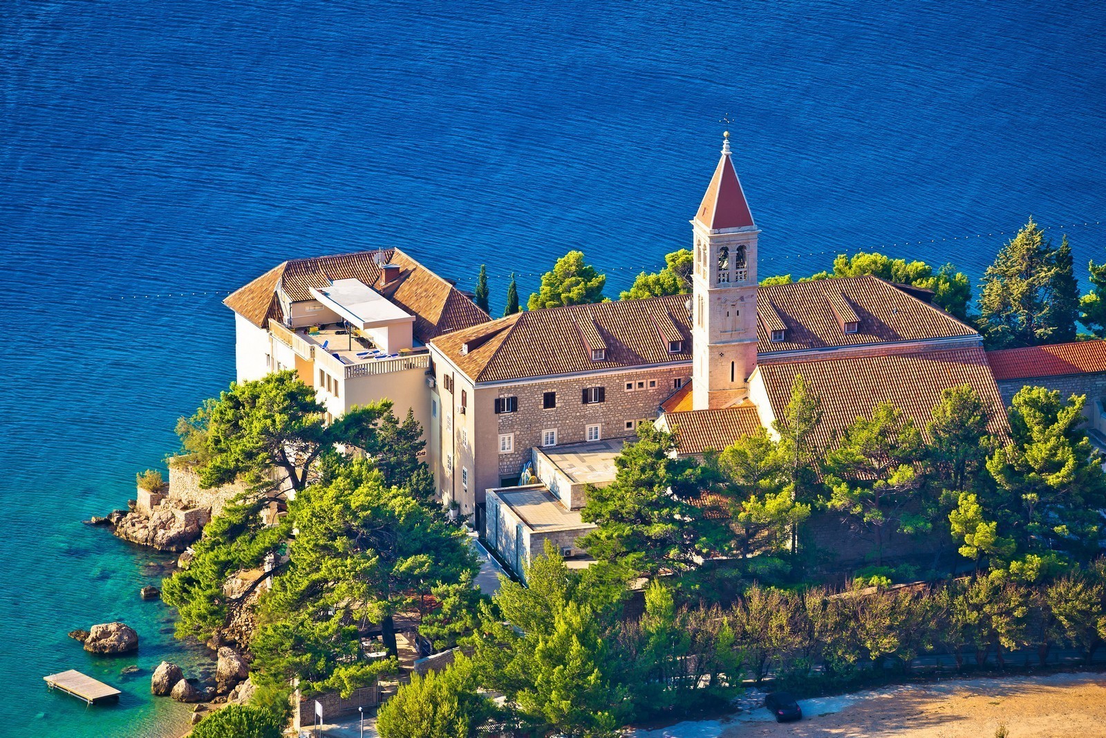
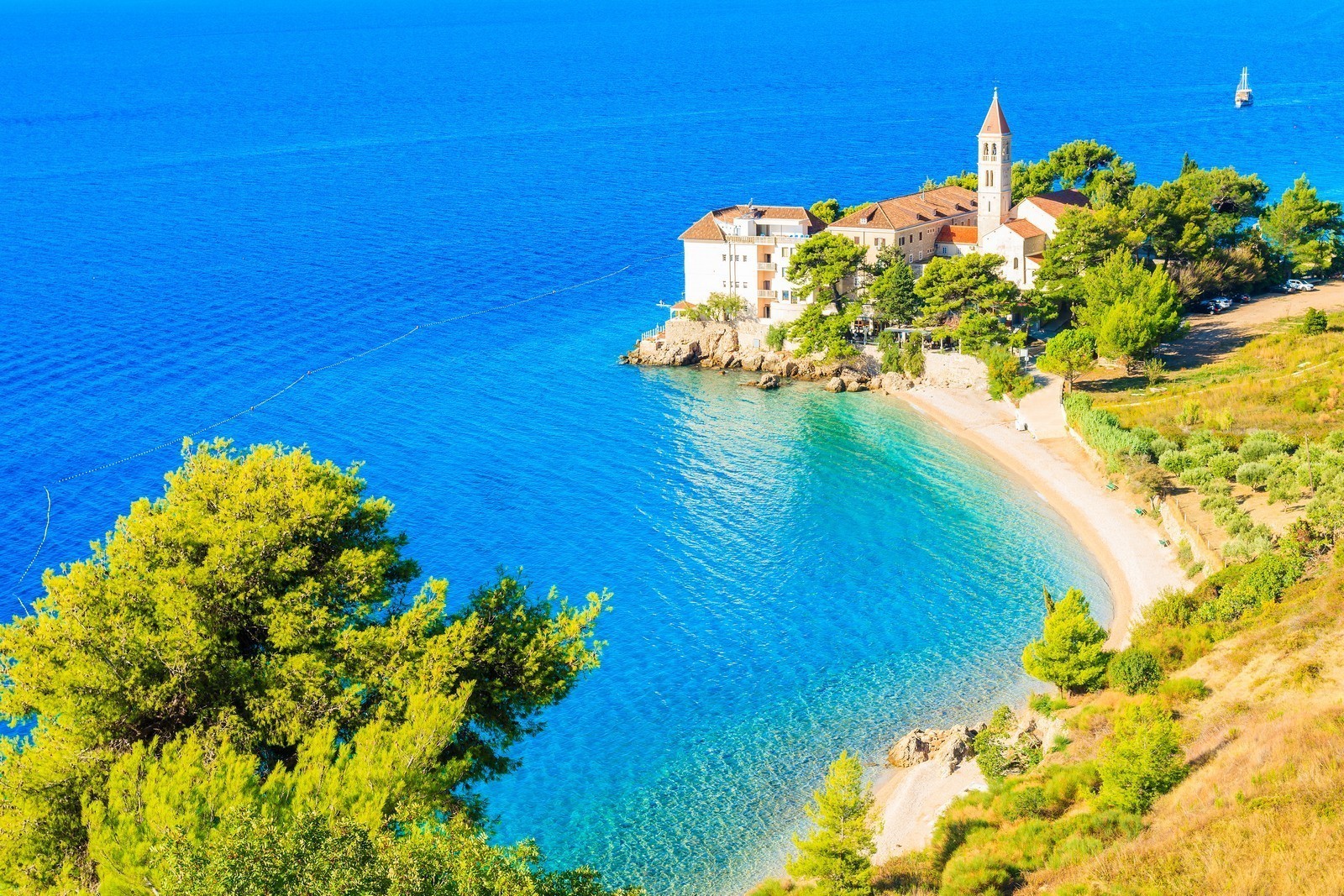
BLACA - The former hermitage of Blaca lies around 2 km north of the bay of the same name. Its Glagolitic monastery is a unique monument and one of the most spectacular day-trip destinations on the island. The 16th century monastery, which is an important architectural masterpiece in itself, also boasts a church, a palace, outbuildings, a rich museum collection and are astronomical observatory. The complex became a museum ant scientific institution in 1963. It can be reached by footpaths from the interior or from the Blaca Bay. The Blaca Bay is uninhabited and provides anchorage at a depth of 7 m. It is exposed to southerly winds.
BOBOVISCA - A settlement on a bay with two arms on the western side of the island of Brac. It is an ideal destination for a peaceful vacation. On an elevation above the settlement stands the pre Romanesque Church of St. Martin with a Gothic bell tower from the 14th century. The Renaissance-Baroque mansion of the Gligo family and the family house of the great Croatian poet Vladimir Nazor stand on the coast. A monument to Vladimir Nazor was erected in the harbor. The settlement with a small 2.5-m-deep harbor lies in the southern arm of the deep, rugged bay. Anchorage is available in the northern arm at a depth of 6 m, where the bottom does not provide a good hold, or in the southern arm. Depending on the position of the boat, the bay is exposed to westerly and northwesterly winds.
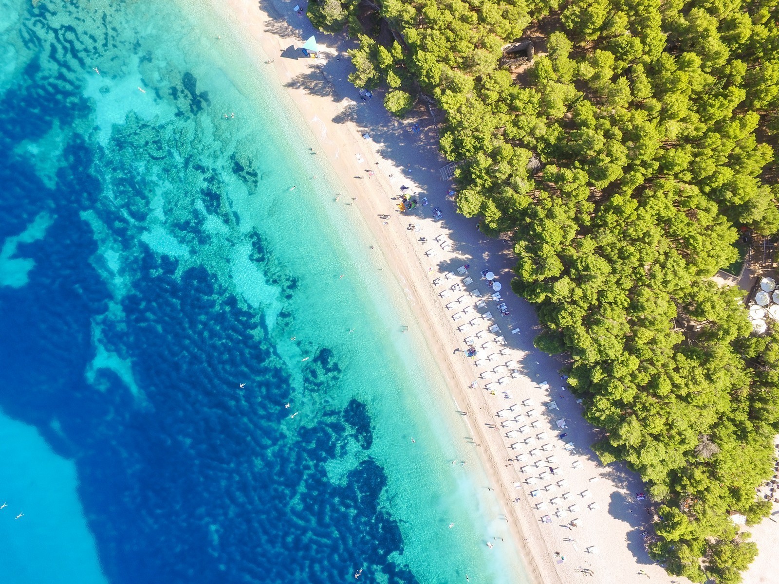
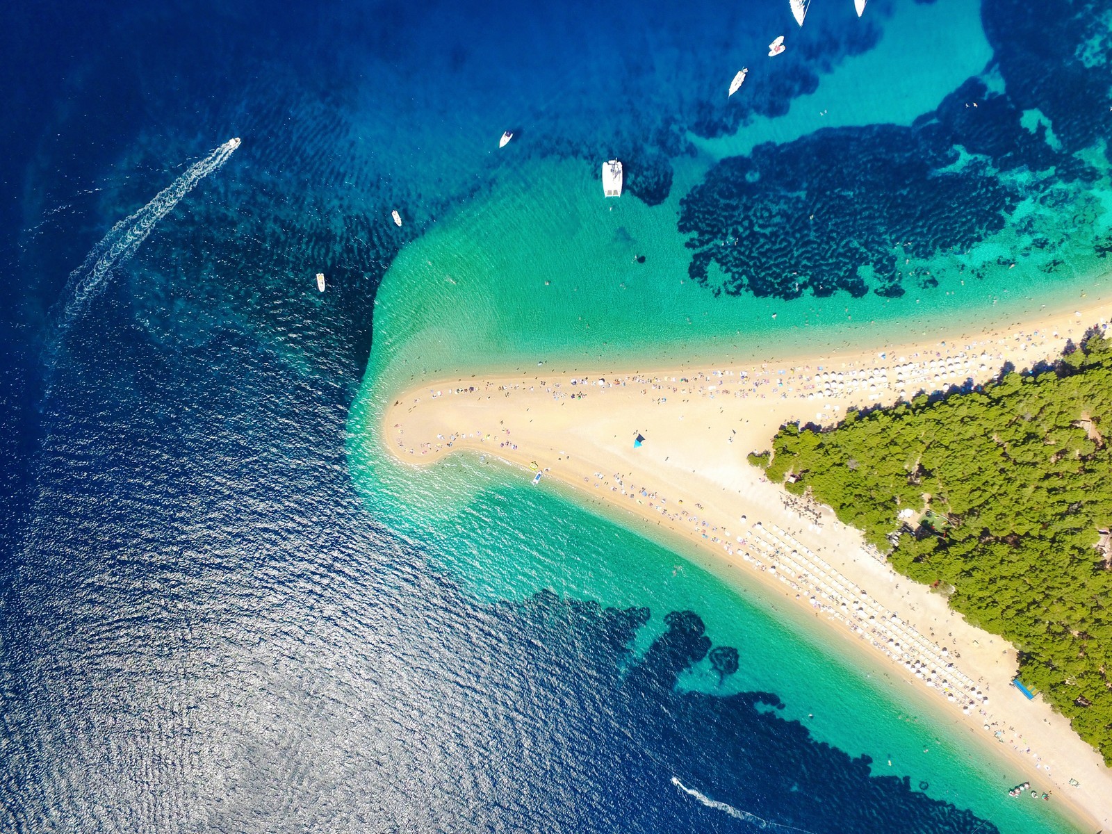
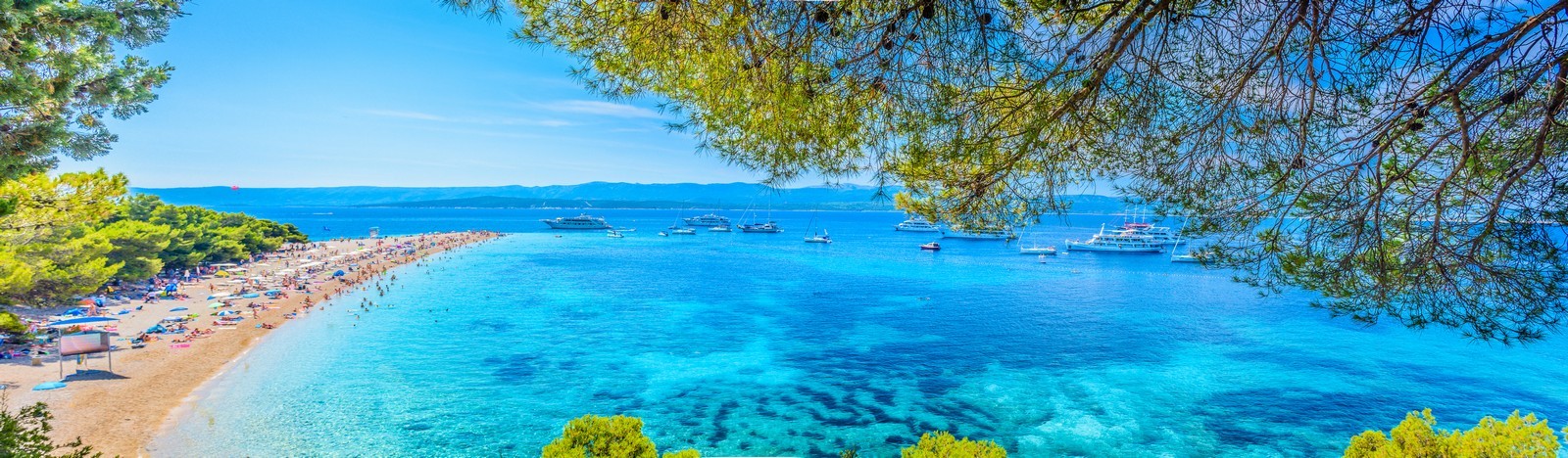
BOL - The only settlement on the southern side of Brac, situated beneath Vidova gora, is the leading tourist resort on the island It is renowned for its wonderful beaches, of which Zlatni rat is one of the most beautiful on the Adriatic and is protected as a natural monument. Bol features diverse sports facilities, including no less than 25 tennis courts and the central tennis stadium where top-level tournaments are held. The Brac Airport is situated on a plateau northeast of Bol at an altitude of 540 m. The runway is 1320 m long and 30 m wide. There are a few private campsites in the settlement and its environs. Bol is the oldest settlement on the island and its history began in the 1st century B.C. its attractions include Roman monuments Early Christian sarcophagi, the Church of sv. Ivan i Tudor (Sts John and Theodore) from the 10th and 11th centuries, the bishop's residence from the 12th century, the Dominican monastery from the 15th century, the Church of sv. Marija (St. Mary) from the 15th to the 17th century, a Renaissance-Baroque palace from the end of the 17th century, and the church of Our Lady of Carmel from 1668-1778. The museum in the Dominican monastery houses an exhibition of prehistoric and ancient navigation. In the Zmajeva (or Drakonjina) spilja Dragon's Cave) near the village of Murvica 4 km to the west, beliefs of a dragon and other cult symbols have been carved into the walls.
The cave is an extraordinary monument of the monastic lives of the Glagolitic priests who lived in the cave in the 15th century. In the port, boats can berth behind the breakwater, which is lastly occupied by local boats. The depth of the sea is 3,5 m. Due to heavy traffic caused by tourist and passenger ships, boats frequently have to be moved, so it is advisable to raft up 3 a tourist ship that is not due to set off in the immediate future, temporary berths are also available at the pier next to the fuel dock. The port is protected by a 140 m long pier and a breakwater, but it is exposed to southerly and southwesterly winds, and the sea is always wavy.
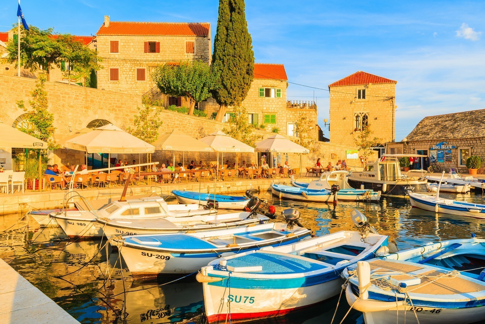
MILNA - A settlement with a port on a bay of the same name on the western part of the island. The main economic activities are agriculture, shipbuilding, fishing, fish processing and tourism, several bays are lined with sandy and pebbly beaches. Milna is not an old settlement, beginnings date back to the 7th century, and the church was built in 1783. It is one of le most beautiful settlements on the island. In 1800, during the Napoleonic Wars, the Russian fleet had an army base here. The port lies on a deep bay which is rugged at the end. In the right, southern arm lies a marina with a shipyard and a fish cannery next to it. With the exception of the marina, there is little pace for berthing. The polluted water (waste from the fish cannery) fosters the growth of numerous shellfish. If your boat is not protected by anti-fouling paint, it is best to avoid Milna. ACI Milna Marina (021) 636 306 - There are 190 berths, 15 spaces for dry storage, a repair shop, 10-ton lift and a launch ramp. The sea is 8 m deep. Private Marina - At the northern side when entering the bay of Milna (always from the west) there is a good private marina with at least 50 berths.
MIRCA - This settlement west of Supetar consists of the fishing village of Gumance on the coast with a settlement of vacation cottages next to it, and a typical old settlement with a church away from the coast. Its small harbor is protected by a knee-shaped breakwater with a depth of up to 2 m, and is exposed to northwesterly winds.
POSTIRA - A town with a port on the northern coast of the island of Brac, known for its fish cannery, fishing and olive oil production. Several interesting bays with beaches surrounded by pine forests lie nearby. Postira was first mentioned in 1347 as Postrena. The settlement expanded in the 16th and 17th centuries with the arrival of refugees from the mainland and inhabitants from the interior of the island. The preserved palace with Renaissance elements in which the writer Vladimir Nazor was born stands in the port. The Parish Church of sv. Ivan Krstitelj (St. John the Baptist) was built in the 16th century. Only the fortified apse has remained of the original building. In the Lovrecina Bay east of Postira lie the ruins of a large Early Christian basilica from the 5th and 6th centuries. The fishing port is protected by a breakwater with a depth of up to 3 m. There is a small pier with a depth of up to 2.5 m in the port which is usually occupied. It is therefore advisable to raft up to a fishing boat. The port is partly exposed to northerly winds.
POVLJA - A settlement on the eastern part of a very rugged bay of the same name on the eastern side of the island. There are numerous picturesque beaches nearby. The Early Christian basilica from the 5th and 6th centuries has been partly preserved. The octagonal baptistery with a dome (the only preserved example in Croatia) is now an integral part of the Parish Church of sv. Ivan (St. John). The remains of the 5th and 6th century frescoes have been preserved. Next to the abandoned church, the Benedictines built a monastery in the 10th century, which was destroyed in 1145 and reconstructed in 1184. The bay has two arms. In the eastern arm lies the settlement with a harbor and a small pier with a depth of up to 3 m. There is a another small pier with a depth of up to 1 m on the opposite coast. This arm is exposed to northwesterly winds. The western arm is exposed to northeasterly winds and provides anchorage at a depth of 10 m. The entire bay is safe for anchoring.
LUKA - A deep bay near Povlja, which forks into three arms at the end. All arms provide anchorage at depths between 3 and 6 m. Depending on the choice of arm, boats can be protected from all winds. Only the bora blows in strong gusts, but there is also buys which you need to pay for.
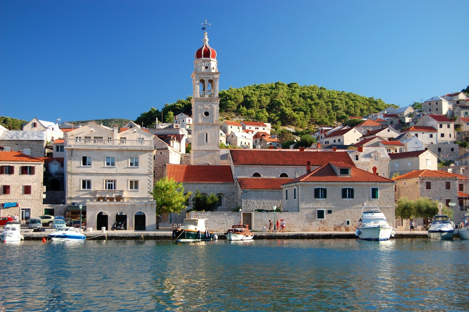
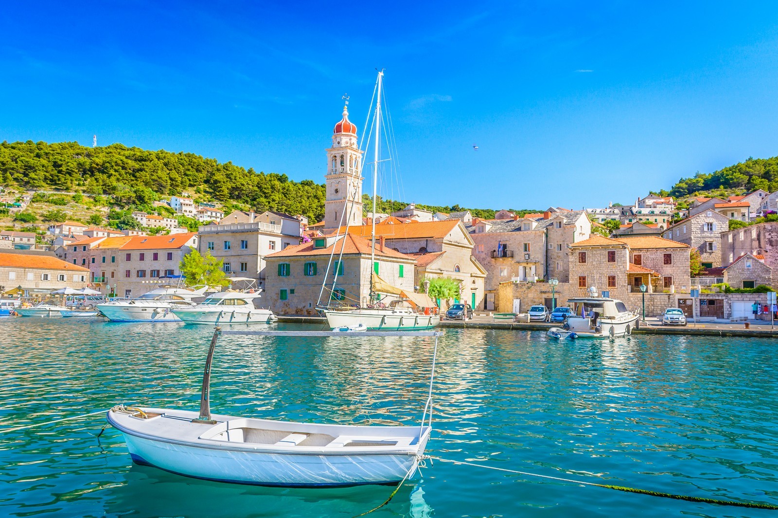
PUCISCA - A large settlement with a harbor on a bay that cuts deep into the northern coast of Brac. There are three quarries with the famous Brae stone nearby, and the settlement is a stone-cutting center. Pucisca was once the most strongly fortified settlement on Brac, built after 1462. Only four of the original thirteen defense fortifications remain in a reconstructed form. The deep bay is rugged at the end. In the eastern part lies a harbor for loading the famous Brae stone, and in the western part lies the settlement with a harbor. The harbor is 4 m deep in the northern part and 3 m deep in the southern. It is exposed to northerly winds, which blow frequently and strongly. In such cases it is best to berth alongside the quay.
SPLITSKA - A settlement with vibrant tourism on a small, peaceful bay on the northern coast of Brac. There are beaches and a pine forest in the Zastup Bay. In the Roman era, the bay was the site of a harbor used for the transportation of stone blocks for Diocletian's Palace in Split. The Rasohe, Plate and Zastrazisce quarries, where the stone blocks were cut, still exist between Skrip and Splitska. A hewn relief of Hercules is still visible in the Rasohe quarry. The present settlement of Splitska was first mentioned in 1553. The preserved Cerinic Castle and the church date from the same period. In the eastern arm of the bay lies the settlement with a harbor which is exposed to northerly winds and has a depth of up to 3 m. The western arm provides anchorage at a depth of 7 m, which is exposed to northeasterly winds and well-protected from the tramontana (N-NW).
SUMARTIN - A settlement and bay on the southeastern coast of the island, A ferry landing (Makarska), tourist ships, fishing boats and visitors of the monastery museum make this small settlement more lively. The coastal settlement was established around 1645 by refugees from the Makarska Riviera who were fleeing from the Turks. The Franciscan monastery from 1747 houses an interesting archive, a museum and a rich library collection. On a nearby elevation stands the Church of sv. Nikola (St. Nicholas) from the 10th century, where services are still held. The port is protected by a breakwater behind which lands the ferry, so the possibility of finding a berth is minimal. It is advisable to raft up to a fishing boat. There is a large inner harbour behind the breakwater, where boats can raft up to local boats with the permission of the locals. The harbour is 3 m deep and is partly exposed to southerly winds.
SUPETAR - A settlement on the northern coast of the island and its administrative, economic, cultural and tourist center. It is considered the gateway to the island. In addition to a regular port, there is also a ferry landing (Split). The settlement offers diverse tourist facilities. The long beaches between the settlements of Mirca to the west and Splitska to the east are sandy and surrounded by pine forests. In the Roman era, there was a settlement on a peninsula where there is now a cemetery, but it fell into ruin. In the Late Middle Ages, a new settlement developed around the small Sveti Petar Bay, after which the settlement was named. Supetar is a typical Mediterranean town in a lovely setting.
The core of the settlement surrounds the Church of sv. Petar (St. Peter) from 1743. The monumental Petrinovic family mausoleum stands on Cape Sveti Nikola in the western part of town. Near the settlement of Donji Humac south of Supetar stands the Church of sv. Ilija (St. Elias) from the 10th and 11th centuries with the remains of a Roman mausoleum made of hewn stone nearby. The port is protected by a knee-shaped breakwater with a ferry landing. The inner part of the port is enclosed by a pier with berths on both sides and a depth of 3 m. The port is only partly exposed to northwesterly winds.
SUTIVAN - A settlement on the western part of the northern coast. It is one of the most beautiful settlements on Brae. Its pebbly beaches are popular with the inhabitants of Split. There is a sandy beach in the Livka Bay at the western edge of Sutivan. The coast has been forested and the gently curving bay is surrounded by a park with a palm-tree colonnade. There is a private campsite in the settlement. There are a few interesting historical buildings in Sutivan. The remains of an Early Christian church from the 6th century lie near the northern wail of the Church of sv. Ivan (St. John) from 1579 which gave the settlement its name. The castle of the Marjanovic family from 1772, the fortified Renaissance house of the Natali-Bozicevic family from 1505 and a 19th century windmill stand on the coast. The harbor, which has little space, is protected by a breakwater with a depth of up to 2.5 m. It is exposed to northwesterly winds.
VIDOVA GORA - The highest peak on Brac and in all the Adriatic islands is 780 m high and lies on the southern side of the island, northwest of Bol. A marked trail leads to the peak from the south. A telecommunications tower and an inn stand at the top, which affords a remarkable view.


We are very social bunch. Get in touch!